


2024 Buyers Guide: Fleet Management Software
Learn what's important when evaluating your options for fleet management solutions.
Read moreGet a near real-time, 360-degree view of your fleet’s daily operations, so you can help reduce costs, increase productivity, stay on top of vehicle maintenance, and make the most of every business day.

Better fleet visibility helps you take stock of what your assets and how they are being used. Our fleet management technology such as GPS fleet tracking software can help businesses keep track of their assets while also maximizing resource utilization.

High-resolution maps with smart clustering and detail on demand provide a simple yet powerful GPS fleet tracking solution to:
Electric vehicle fleet tracking
Get electric vehicle (EV) fleet tracking details in near real-time on a live map, including charging status, battery-level percentage and location. Set up low-battery alerts and review reports to help improve utilization of your electric vehicle fleet and sustainability efforts. See which of your internal combustion engine vehicles are best suited to be converted to EVs.

Reveal only
See important trends by team, department or across the entire fleet. Our customizable dashboards make it easy to review your progress towards KPIs or budgets, with near real-time fleet analytics provided by our GPS fleet tracking software.


For fleet owners looking for a vehicle tracking solution that is simple to use and addresses common pain points such as high fuel costs, worker productivity, driver safety, compliance and asset security.
With a range of setup options and an affordable monthly price, you can enjoy all the benefits of a powerful fleet tracking solution from one of America’s largest telematics providers.

With Verizon Connect, I was able to implement the metrics that I wanted to control my job cost and profit.

With Verizon Connect, I was able to implement the metrics that I wanted to control my job cost and profit.

Customer Support
To help you save time, Verizon Connect offers various support options that don’t require you to contact customer service.
Reveal only
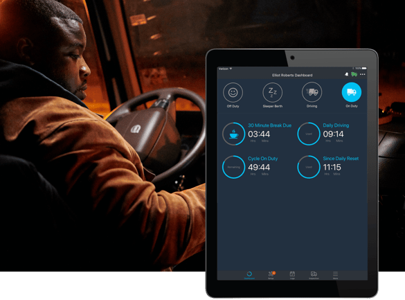
An electronic logging device (ELD) helps truck drivers manage compliance with federal regulation for recording on-duty/off-duty status and breaks.
Our fleet tracking hardware connects directly to the vehicle to help improve the accuracy of hours of service (HOS) logs and reduce the likelihood of fines for missing data.
Reveal only
Let drivers compete for positions on the company leaderboard by driving safely, productively and efficiently. Connect driver and commercial vehicle tracking data to locate your crew and help coach them on safe driving behaviors.
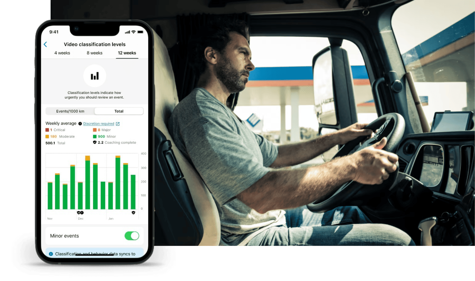
View video clips of harsh driving events within minutes of them happening. Know how severe an event was with harsh driving classifications to help you boost driver safety and coach your drivers. Help mitigate risk and liability with unbiased footage.

Reveal only
Our GPS fleet tracking mobile app allows you to take your business wherever you go.1 View vehicles and assets on a live map, locate a driver, see vehicle activity and route history, and receive alerts on driver behaviors.
Learn what's important when evaluating your options for fleet management solutions.
Read moreBuyer's Guide: Asset Tracking Solutions
Read more
The City of San Jose needed a software platform to improve dispatching, allow officers to easily find an available car...
Read moreDashcams and smart video backed by AI and machine learning help fleet managers make a positive impact on fleet safety...
Read moreFleet tracking is a management system that uses GPS to monitor the activity of tracked assets (vehicles, workers, equipment). It is often referred to as vehicle tracking or AVL. The fleet is generally a collection of land-based assets such as cars, trucks, field workers and equipment (powered and unpowered e.g. trailers).
Fleet tracking uses telematics technology to collect data from a fleet of assets. This data is normally collected in near real time (actively) so it is more useful for fleet managers, who use the data to make strategic decisions about operations (which vehicle should I dispatch to a new job, where is the nearest crane, how many generators do we have in the yard, has my lone worker returned from the jobsite etc).
Electronic Logging Devices (ELDs) have replaced paper HOS logbooks and are now legally required by commercial drivers. We offer a range of ELD solutions and have several devices certified with the FMCSA.
We work hard to make our GPS fleet tracking software is nice to look at, user friendly and focused on helping you get stuff done. When you join us, we guide you every step of the way with our new user onboarding program and access to lots of training guides if you need them.
We also have local support teams who can assist you, either over the phone or via email.
Yes, it’s powerful vehicle tracking system software with lots of features but it’s also designed to be quick and easy to use for anyone who just likes to ‘get in and drive.’
No. The great thing with GPS fleet tracking software built as a Software-as-a-Service (SaaS) is that all you need is a computer that can connect to the internet running a modern browser.
You can even use just your Android or Apple device to access key information about your fleet vehicles and today’s jobs.
Only if you want to. Our GPS fleet tracking software offers plenty of options for managers on the go, including mobile apps and alerts that go directly to your phone. You’ll have quick access to a range of key information about your fleet’s current performance, wherever your day takes you.
There are lots of GPS fleet tracking providers who only sell one thing. It means if you need something else for your fleet – ELD, route planning, dispatch, work order management – then you need to go through the whole selection process again and deal with another supplier. And then if you want these different solutions to talk to each other, that’s a whole other conversation.
Verizon Connect is one of the few providers that can provide you with a full end-to-end platform solution that covers your mobile resource management needs now, and into the future.
In most cases it depends on the reasons why you want to use GPS fleet tracking, and how you explain near reatime GPS trackers to them. If you want to use it to improve the efficiency, security and safety of your business, and help mobile workers to get more done, with less paperwork and phone calls, then most employees will understand that. They’ll also appreciate you’re making an effort to keep the business profitable and improving their job security. If they think it’s been done because you don’t trust them then they may not be as welcoming.
We understand that as your business grows our software needs to adapt. Our flexible platform and access to the full range of mobile resource management products makes it easy to add solutions over time.
Simply contact your customer success manager and discuss your new requirements.
We supply standard GPS fleet tracking units that are wired directly into the tracked asset, allowing the device to be hidden to help prevent tampering, as well as being compatible with vehicles or equipment that don’t have an OBD port.

Run historical reports on up to 2 years of fleet data to uncover insightful trends, support investigations and extrapolate reliable forecasts. Cloud-based storage is regularly backed up and replicated.

View video clips of harsh driving events within minutes of them happening. Know how severe an event was with harsh driving classifications to help you coach your drivers. Help mitigate risk and liability with unbiased footage.

Easily replay historical events to improve the speed and efficiency of internal investigations for damage claims or accidents.

Set up hour tracking to manage legal driving hours and help improve the accuracy of trip scheduling to keep drivers within legal HOS limits.

Monitor and manage all types of mobile equipment to help improve safety, security and utilization. AEMP-compatible.

Replay your vehicles’ route history for specific dates and follow the actual routes taken by drivers. Show specific events, such as speeding or stops, and compare drivers’ performance.

Integrate with other enterprise systems, such as SAP, using standard web-based APIs (REST,SOAP etc.). Help improve the speed and accuracy of data collection for your payroll, HR and CRM solutions.

Set custom alerts for your drivers based on speeding, idling, harsh braking, and more. Want drivers to slow down in the rain or snow? Trigger a lower-limit speeding alert when the vehicle wipers are active.

Get valuable insight on map locations with the most current and comprehensive satellite imagery commercially available. Includes both Streetside and Birds Eye views for extra detail. New images added daily.

Show interactive GIS data (such as power or sewer lines, land use grids or parcel data) as a map layer. Supports ESRI Shapefile, MapInfo MID/MIF, Autodesk DXF).

Find out which equipment could be getting you a better return. Relocate or sell unused assets, and help improve the ROI on what you’ve got.

Easily find a vehicle, driver, location or tagged group using the powerful search function that automatically updates the map based on your query.

Securely share a restricted view of your fleet activities to third parties. Set limits on what data can be seen and for how long. Ideal for work order confirmation, storm recovery or disaster response work.

Build custom workflow scripts that can be triggered based on multiple conditions.

Change what things are called in the app, so it matches how you talk about your business. For example, change driver to field technician or vehicle to crane.

Go global with multiple language support, including Portuguese, Spanish, Chinese and Arabic. Tag assets to specific time zones for more accurate reporting.

Combine all your mobile workforce software on a single platform for improved operational efficiency and data sharing. A true end-to-end connected intelligence platform.

Find training opportunities by analyzing driver behavior over time. Each driver gets a unique key fob, required for each journey.

Track fuel card usage and automatically identify suspicious transactions using smart algorithms that help identify and reduce fuel card fraud.

Set up customized access and security levels to meet the needs of your organization. Create unlimited users and assign them to specific groups for easier management.

Generate vehicle maintenance alerts for your own service department or local dealer. Help improve the accuracy of your preventative maintenance program to control costs.

Get your free 2024 Fleet Technology Trends Report and see how organizations are: